Concrete Scanning (Concrete X-Ray)
Utah County • Tooele County • Salt Lake County
Call, text or email to schedule your scan today.
Call: (385) 253-1776 |
Email: kevin@gprservicesinc.com
What is Concrete Scanning?
Concrete scanning with ground penetrating radar (GPR) is used to locate and map the positions of metallic and nonmetallic materials such as rebar, post-tensioning cables, conduit, metal and plastic pipes, electrical cables, and other near-surface anomalies and objects in concrete. The reliability of concrete scanning is greatly improved with the use of ground penetrating radar (GPR). GPR is a radar-based technology that uses antennas to transmit and receive pulses of electromagnetic energy through a medium such as the ground or concrete. These reflected waves are then detected by the radar equipment and allow very accurate determination of the locations of objects within the concrete.
Benefits of Concrete Scanning
There are a variety of benefits of concrete scanning when you choose to have the scan done before you start a project involving concrete. Some of the benefits include the following:
- Save time you might have spent test drilling to locate materials in the concrete.
- Avoid potentially disastrous and costly hits on critical reinforcement within the concrete.
- Avoid personal injury, work-time delays, and damages to concrete structures.
- Increase the working life of your tool motors and drill/core bits.
- Reduce drilling times important in repetitive drilling applications
- Maintain a safer environment at the job site for you and your employees.
Concrete Scanning Applications
Technical Specifications
Concrete Scanning Results
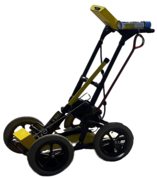
Our Technology
Concrete Scanning Applications
Concrete scanning is useful in a variety of applications. These include, but are not limited to, the following:
- Non-destructive inspection and analysis of concrete structures, on-site and in real-time view (prior to drilling, cutting, and coring).
- Detect metal objects (such as rebar, post-tension cables, metal/copper/aluminum pipes) and non-metal objects (such as wood, plastic pipes, electrical conduits, glass-fiber cables) embedded in concrete.
- Locate air cavities and other anomalies in the concrete.
- Detect objects in multiple layers, depending on the condition of the concrete; determine rebar mesh spacing, object size, and depth.
- Verify slab thickness and determine the depth of material cover on reinforcement.
- Identify safe drill and core locations.
- Quality control.
- Project acceptance.
- Changing occupancy.
- Repetitive drilling/fastening applications.
- Verify position, quality, or existence according to plans.
- Identify location of sub-surface heating systems.
Technical Specifications
- Ability to combine multiple data sets and create a single scan of an area as large as 135′ x 135′ for analysis and visual presentation.
- Non-destructive structural reinforcement analysis, accurate within +/- 0.1 inch of actual location.
- Determine rebar depth in concrete, accurate within +/- 0.04 inch.
- Accurately determine rebar diameter for rebar up to 2.4 inches deep in concrete.
- Determine concrete thickness up to 4 feet 5 inches, accurate within 5 percent.
- 2D and 3D object visualization in multiple layers up to 18” deep with an accuracy of +/- 0.5 inch in concrete structures.
- Accuracy of depth indication: in thicknesses less than 4 inches, accurate within +/- 0.5 inches; in thicknesses greater than 4 inches, accurate within +/- 15 percent.
Note: We can locate electrical conduits (PVC or metal), but we cannot identify the material class. Only the object layout, approximate depth, geometry, and position of the conduit can be identified. Our equipment is designed to locate objects, not to identify object class (material).
Concrete Scanning Results
With our technology, we are able to scan (x-ray) large areas quickly and provide immediate, high-resolution 3D images of our findings for comprehensive and immediate analysis of concealed objects. These images will help you determine where to drill, cut, or core to avoid hitting objects in the concrete. Using PROFIS Ferroscan MAP software, we have a variety of report and data analysis options to ensure you are getting an accurate picture of what is actually in the concrete structure.
Our Technology
C.R.I., Inc. performs all concrete scanning (concrete x-ray) using the latest technology in ground penetrating radar and electromagnetic technology with equipment from Hilti. Our current equipment includes the Hilti PS200 Ferroscan and the Hilti PS1000 X-Scan.